St Lucia
>St Lucia
>Vieux Fort Hotels
>
Info
Hewanorra International Airport 1 hr 7
Mount Gimie (56 min)
St. Lucia's highest mountain, with forested slopes & guided summit hikes to commanding island views.
Vigie Beach (25 min)
Laid-back sandy stretch in a calm bay, with snack vendors, bars & plane-spotting opportunities.
Anse Chastanet Beach (57 min)
Popular, laid-back beach featuring coral reef snorkeling, calm waters for swimming & mountain views.
The Tet Paul Nature Trail (58 min)
Hillside nature trail offering a picturesque viewpoint of the water & mountains, plus guided tours.
Mount Fortune (18 min)
Summit ridge with remains of the 19th-century Apostles Battery, plus views over the cruise port.
Gros Piton (1 hr 8)
This 798-m. mountain offers panoramic views from its summit, which can be reached by hiking.
Pigeon Island (43 min)
Islet connected to the mainland via a causeway & featuring a beach & the ruins of historic forts.
Anse Cochon Beach (25 min)
Castries Central Market (21 min)
Bustling collection of vendors selling handicrafts, prepared foods & native fruits & vegetables.
Choc Bay (30 min)
Broad bay lined with sandy beaches overlooked by upscale resort hotels & dense forest vegetation.
Diamond Botanical Gardens (52 min)
Former plantation-turned-park with many ornamental plants, a waterfall & geothermal mineral baths.
Reduit Beach (37 min)
Lively, narrow stretch of sand with swimming, chair rentals & water-sport options.
Pigeon Island National Park (43 min)
Forested cape with 18th-century Fort Rodney, military remains & Martinique views from Signal Hill.
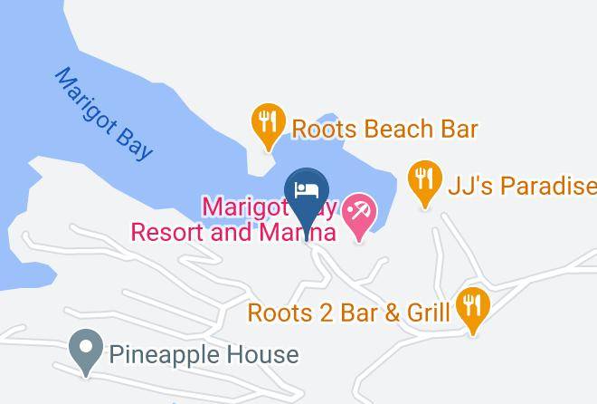
Marigot Bay (12 min)
Charming harbor featured in the 1967 film “Dr. Dolittle,” with resorts, restaurants & kayaking.
Rodney Bay (42 min)
Large bay featuring a white-sand beach, a marina with yacht docks, a water park & more.
Contact Number
Web Site
Address
Map Coordinates
Map