Czechia
>Hradec Kralove
>Trutnov Hotels
>
Info
Pardubice Airport 1 hr 37
The Timber Trail, Krkonoše (9 min)
Panoramic forest views from a tall, tornado-shaped tower with a long slide down from the top.
Krkonoše National Park (49 min)
Mountainous national park & UNESCO-listed biosphere containing the Czech Republic's highest peak.
Równia pod Śnieżką (49 min)
Sněžka (49 min)
Popular hiking spot on the border of Poland & the Czech Republic, the highest peak in the latter.
Růžová hora (49 min)
Clad in conifers, this summit is home to the mid-station of the Sněžka mountain cable car.
Špindlerův Mlýn Ski Resort (50 min)
Ski resort with slopes, snow parks, instruction & equipment rentals, plus bars, restaurants & shops.
Ski Resort Černá Hora (15 min)
Ski area with more than 50km of slopes, plus bike & scooter rides though woods & meadows in summer.
Černá hora (32 min)
Mountain featuring a resort that offers skiing, a toboggan run, snowboarding & more.
Mały Staw (57 min)
Lake, glacier, and mountain
Herlíkovice Ski Resort (40 min)
Sprawling recreation area with winter skiing & snowboarding, plus hiking & cycling in summer.
Wang Church (1 hr 13)
12th-century church, constructed similarly to Viking longships & moved to this site in 1842.
Kleine Koppe (1 hr 12)
Peak on the Polish side of the Giant Mountains with conifer forests & chair lift from 1959.
Giant Mountains (1 hr)
Rising to 5,259 feet, this scenic mountain range features ski resorts & trails for hiking & biking.
Studniční hora (55 min)
Fort Stachelberg (32 min)
Czech history exhibits in a vast, 20th-century fortress with a lookout tower & kids' playground.
Contact Number
Web Site
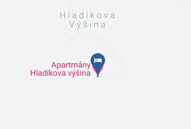
Title :
Address
Map Coordinates
Map