Japan
>Tochigi Pref
>Nikko City Hotels
>
Info
Fukushima Airport 2 hr 27
Lake Chūzenji (20 min)
Scenic lake, discovered in 782, with summer hiking & boating, fall leaf watching & winter sports.
Kegon Falls (22 min)
97-m. waterfall plunging over a forested cliff, with an elevator (fee) to a lower viewing area.
Mount Nikkō-Shirane (17 min)
Volcanic mountain in the Nikkō National Park offering hiking, climbing & backcountry skiing.
Nikkō Tōshō-gū (47 min)
Opulent 17th-century shrine complex honoring the first shogun & featuring colorful buildings & art.
Okunikkō (41 min)
Autumn leaf color, lake, waterfall, hiking, and mountaineering
Yutaki Falls (5 min)
Waterfall over 70 m. high, with an observatory platform that enables visitors to get a good view.
Ryuzu Falls (13 min)
Popular pair of cascades reachable by a short hiking trail, with a nearby restaurant & gift shop.
Mount Nantai (38 min)
Many hikers make the 8156 ft. climb up this stratovolcano that was redesignated as 'active' in 2008.
Senjogahara (8 min)
Scenic hiking destination with raised trails offering views of the surrounding valley & mountains.
Nikko National Park (6 min)
National park with scenic trails by volcanic mountains, lakes, reservoirs, falls & wetlands.
Nikko Futarasan jinja (47 min)
Mountain-top Shinto shrine with precinct & gardens, dating from the 8th century.
Rin-no-ji Treasure House (47 min)
Buddhist temple complex, established in 766 CE, with a museum & classical Edo-era landscape garden.
Yuno Lake (14 min)
Picturesque clear-water lake known for its autumn colors with a trail around its 1.9-mile shoreline.
Odashirogahara (11 min)
Exposed mountain pass with views over wooded peaks, known for challenging hiking & biking routes.
Contact Number
Web Site
Title :
Address
Map Coordinates
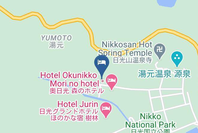
Map