Poland
>Malopolskie
>Tatrzanski Hotels
>
Info
John Paul II Kraków-Balice International Airport 1 hr 49
Dolina Pięciu Stawów Polskich (3 hr 31)
Valley with popular hiking routes past lakes & waterfalls, offering spectacular mountain scenery.
Nosal (22 min)
Rising 1,206 m. above sea level, this forested mountain offers skiing, hang-gliding & paragliding.
Lomnický štít (1 hr 20)
Snow-capped mountain range peak reaching 8,642-feet with an observatory built in 1940 & cable cars.
Zelené pleso (1 hr 20)
Vast nature reserve with a scenic, moderate hike to its lake & traditional mountain chalet.
High Tatras (1 hr 33)
Sprawling mountain chain with dozens of scenic peaks, alpine lakes & a variety of hiking trails.
Giewont (35 min)
Popular with hikers, this mountain massif in Tatra National Park features 3 peaks & marked trails.
Belianske Tatras (21 min)
Alpine range with a peak elevation of 2,152 m. offering overnight accommodations in its foothills.
Tatra National Park, Poland (24 min)
Expansive, mountainous national park with lakes, caves, wildlife & miles of scenic hiking trails.
Gubałówka (43 min)
Majestic mountain offering hiking trails & a cablecar to the top, with panoramic views of the area.
Gerlachovský štít (1 hr 33)
The tallest High Tatras mountain range peak rising 8,709 feet over a glacial valley.
Dolina Gąsienicowa (21 min)
Picturesque valley for hiking amid pine trees, meadowland & a dramatic mountain backdrop.
Morskie Oko (3 hr 20)
Scenic views feature at this tree-ringed lake, the largest & fourth-deepest in the Tatra mountains.
Popradské pleso (1 hr 5)
Surrounded by woods & mountains, this picturesque lake also features trails, a lodge & restaurant.
Ski resort Kotelnica Białczańska (19 min)
Popular ski resort offering many downhill & cross-country trails, a snowboard park & eateries.
Skalnaté Pleso (1 hr 2)
Mountain tarn at 5,745 ft. served by cable car, with food & gift outlets & a scientific observatory.
Contact Number
Web Site
Title :
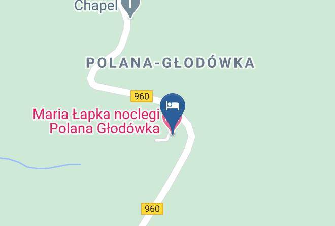
Address
Map Coordinates
Map